.\
cggooglemapwidget__define.pro
Graphics
This is a compound widget object that obtains a Google static map from Google Maps and displays it in the program's draw widget window. It can be used either as a stand-alone program or to create a map image in draw widget in a larger widget program.
This program implements a subset of the Google Static Map API, which can be found in more detail here: https://developers.google.com/maps/documentation/staticmaps/. The program works by building a URL for a map image. A connection to the Internet is required to then request a map image (in JPEG or PNG format) to be returned from Goggle Maps. The returned image is then read and loaded into a draw widget window of the right size for the returned map image. The default is to delete the image file that is created, but user can also set keywords to retain the image that is downloaded from Google Maps. Users are able to control button and motion events in the resulting draw widget with their own event handler module. A cgMap coordinate object is created to establish a map reference coordinate system on top of the returned map image, allowing other map information to be drawn on top of the returned map image.
Examples
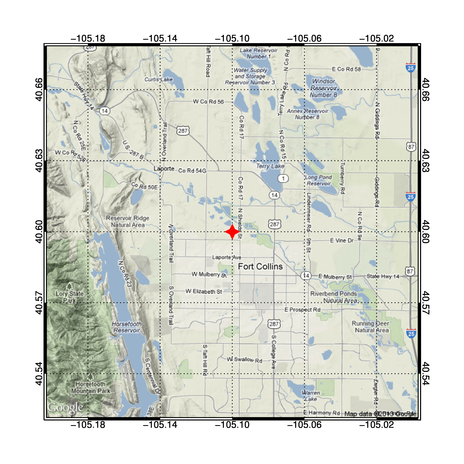
Used to put two markers on a map of Fort Collins, Colorado, in a stand-alone window:
   PRO cgGoogleMapWidget_Test
       marker1 = {cgGOOGLEMAPMARKER, 'normal', 'dodger blue', 'A', Ptr_New(40.600), Ptr_New(-105.100)}
       marker2 = {cgGOOGLEMAPMARKER, 'normal', 'purple',      'B', Ptr_New(40.605), Ptr_New(-105.105)}
       googleObject = Obj_New('cgGoogleMapWidget', MARKERS=[marker1, marker2], MAPTYPE='Terrain')
   END
Class description for cgGoogleMapWidget
Properties
Properties in cgGoogleMapWidget
- EVENT_PRO set init
- MOTION_EVENTS init
- BOX_AXES init
- MARKERS get set init
- XSIZE get init
- YSIZE get init
- CENTER_LONGITUDE get set init
- KEEP_IMAGE init
- EVENT_METHOD get set init
- MAPIMAGE get
- IMAGETYPE get set init
- VISIBLEMARKERS set init
- DRAW set
- WID get
- FILENAME get
- TEMPDIR init
- MAPCOORD get
- MAPTYPE get set init
- MAPPOSITION get
- BUTTON_EVENTS init
- CENTER_LATITUDE get set init
- ZOOMLEVEL get set init
Fields
Fields in cgGoogleMapWidget
- CENTERLON 0.00000000D
- EVENT_PRO ''
- BOX_AXES 0B
- MARKERS ptr_new()
- XSIZE 0L
- YSIZE 0L
- KEEP_IMAGE 0B
- EVENT_METHOD ''
- MAPIMAGE ptr_new()
- IMAGETYPE ''
- VISIBLEMARKERS 0B
- MAP_POSITION [0.000000, 0.000000, 0.000000, 0.000000]
- WID 0L
- DRAWID 0L
- FILENAME ''
- TEMPDIR ''
- MAP_XSIZE 0L
- MAP_YSIZE 0L
- MAPCOORD obj_new()
- RANDOM obj_new()
- MAPTYPE ''
- TLB 0L
- CENTERLAT 0.00000000D
- ZOOMLEVEL 0S
Author information
- Author
FANNING SOFTWARE CONSULTING:
David W. Fanning 1645 Sheely Drive Fort Collins, CO 80526 USA Phone: 970-221-0438 E-mail: david@idlcoyote.com Coyote's Guide to IDL Programming: http://www.idlcoyote.com- Copyright
Copyright (c) 2012, Fanning Software Consulting, Inc.
- History
Change History:
  Written, 25 June 2012. DWF.
  Set the RETAIN keyword on the draw widget for UNIX machines. 28 June 2012. DWF.
  Beefed up and changed error handling when failing to obtain a map from Google Maps. 28 June 2012. DWF.
  Added NoForwardFix keyword to call to cgMap to allow better drawing of markers. 29 June 2012. DWF.
  Added the ability to turn markers on or off with VisibleMarkers keyword and property. 29 June 2012. DWF.
  Added a WID keyword to the GetProperty method to all the user to obtain the Goggle Map
      window index number. 29 Aug 2012. DWF.
Routines
result = cgGoogleMapWidget::INIT( [parent] [, /BOX_AXES] [, /BUTTON_EVENTS] [, CENTER_LATITUDE=float] [, CENTER_LONGITUDE=float] [, EVENT_METHOD=string] [, EVENT_PRO=string] [, IMAGETYPE=string] [, /KEEP_IMAGE] [, MAPTYPE=string] [, MARKERS=structure] [, /MOTION_EVENTS] [, TEMPDIR=string] [, /VISIBLEMARKERS] [, XSIZE=int] [, YSIZE=int] [, ZOOMLEVEL=integer])This is the initialization method of the cgGoogleMapWidget object.
cgGoogleMapWidget::CLEANUPThe clean-up method for the object.
cgGoogleMapWidget::CreateMapCoordObjectThis method creates a cgMap map coordinate object for georeferencing the map image returned by Google maps.
cgGoogleMapWidget::Draw [, /SUCCESS]The purpose of this method is obtain the map from Google as an image and display it in the draw widget window.
cgGoogleMapWidget::DrawWidgetEvents, eventThe purpose of this method is handle draw widget events.
result = cgGoogleMapWidget::GetMapCoord( [/UPDATE])This method returns the map coordinate object that sets up the georeferencing coordinate system (in projected meter space) for drawing on top of the map image.
cgGoogleMapWidget::GetProperty [, CENTER_LATITUDE=float] [, CENTER_LONGITUDE=float] [, EVENT_METHOD=string] [, FILENAME=string] [, MAPIMAGE=bytarr] [, IMAGETYPE=string] [, MAPPOSITION=fltarr] [, MAPCOORD=object] [, /MAPTYPE], MARKERS=MARKERS, WID=WID [, XSIZE=int] [, YSIZE=int] [, ZOOMLEVEL=integer]The properties of the object are retrieved with this method.
cgGoogleMapWidget::Map_Type, eventThe purpose of this method is to display a map with a particular map type.
cgGoogleMapWidget::Notify_RealizeThe purpose of this method is to draw the initial map plot in the draw widget.
cgGoogleMapWidget::SetProperty [, CENTER_LATITUDE=float] [, CENTER_LONGITUDE=float] [, /DRAW] [, EVENT_METHOD=string] [, EVENT_PRO=string] [, IMAGETYPE=string] [, MAPTYPE=string] [, MARKERS=structure] [, /VISIBLEMARKERS] [, ZOOMLEVEL=integer]The purpose of this method is to set some of the object's properties.
cgGoogleMapWidget::SetWindowThe purpose of this method is to make the draw widget window the current window.
cgGoogleMapWidget::Zoom_In [, event]The purpose of this method is to zoom into the map by increasing the zoom factor.
cgGoogleMapWidget::Zoom_Out [, event]The purpose of this method is to zoom out of the map by decreasing the zoom factor.
cgGoogleMapWidget_Notify_Realize, idThis is the realize notify routine for the widget.
cgGoogleMapWidget_Cleanup, tlbThis is the cleanup routine for the widget.
cgGoogleMapWidget_Events, eventThis is the main event handler for the program.
cgGoogleMapWidget__Define [, class]The object class definition for the cgGoogleMapWidget class.
Routine details
top cgGoogleMapWidget::INIT
result = cgGoogleMapWidget::INIT( [parent] [, /BOX_AXES] [, /BUTTON_EVENTS] [, CENTER_LATITUDE=float] [, CENTER_LONGITUDE=float] [, EVENT_METHOD=string] [, EVENT_PRO=string] [, IMAGETYPE=string] [, /KEEP_IMAGE] [, MAPTYPE=string] [, MARKERS=structure] [, /MOTION_EVENTS] [, TEMPDIR=string] [, /VISIBLEMARKERS] [, XSIZE=int] [, YSIZE=int] [, ZOOMLEVEL=integer])
This is the initialization method of the cgGoogleMapWidget object.
Parameters
- parent in optional type=long
The identifier of the parent widget of the draw widget that is going to be created by the program. If not provided, the program will create its own top-level base widget as the parent.
Keywords
- BOX_AXES in optional type=boolean default=0
Set this keyword to draw box axes around the Google Map.
- BUTTON_EVENTS in optional type=boolean default=0
Set this keyword to turn button events on for the draw widget in the program.
- CENTER_LATITUDE in optional type=float default=40.60
The center latitude of the requested Google map. If not provided, the latitude of Fort Collins, Colorado, home of Coyote. Latitudes are only recognized to four decimals values of precision.
- CENTER_LONGITUDE in optional type=float default=-105.10
The center longitude of the requested Google map. If not provided, the longitude of Fort Collins, Colorado, home of Coyote. Longitude are only recognized to four decimals values of precision.
- EVENT_METHOD in optional type=string
The name of the event handler method (a procedure) for the draw widget. If you use this keyword, you will also need to write this event handler module. It gets sent one positional parameter, the event structure created by the draw widget.
- EVENT_PRO in optional type=string
The name of an external event handler procedure for the draw widget. The event handler procedure gets sent one positional parameter, the event structure created by the draw widget.
- IMAGETYPE in optional type=string default=png32
The type of image format the Google map should be returned in. The default is a 32-bit full color PNG file. The image types are given in the Google Static Map API documentation and are as follows: png or png8, png32, gif, jpg, and jpg-baseline.
- KEEP_IMAGE in optional type=boolean default=0
Set this keyword if you wish to save the Google map as an image when the object is destroyed.
- MAPTYPE in optional type=string default=terrain
Set this keyword to the type of map you wish to retrieve from Google Maps. The choices are listed in the Google Static Map API documentation and are: "roadmap", "terrain", "satellite", and "hybrid".
- MARKERS in optional type=structure
A scalar or array of cgGoogleMapMarker structures. If present, the markers will be requested with the map from Google. The cgGoogleMapMarker structure is defined like this:
Note that the user will be responsible for freeing the pointers in the MARKERS structure. This program will not do that.struct = { cgGOOGLEMAPMARKER, $ size: "", $ ; The marker size ("tiny", "small", "mid" or "normal") color: "", $ ; A color name as provided by cgColor. label: "", $ ; A single uppercase character label from the set {A-Z,0-9}. lats: Ptr_New(), $ ; A pointer to one or more latitude values. lons: Ptr_New() } ; A pointer to one or more longitude values.- MOTION_EVENTS in optional type=boolean default=0
Set this keyword to turn motion events on for the draw widget in the program.
- TEMPDIR in optional type=string
The directory where the image containing the Google map is written. By default, it is obtained from the environment like this: tempdir = GetEnv('IDL_TMPDIR').
- VISIBLEMARKERS in optional type=boolean default=1
Set this keyword to 0 to temporarily turn off the display of the markers. Normally, markers are drawn (if present), unless this flag is set to 0.
- XSIZE in optional type=int default=600
The X size of the program's draw widget. A maximum of 690 if box axes are requested and a maximum of 640 if no box axes are requested. Box axes require a 25 pixel border and the maximum size of a Google Map is 640 pixels.
- YSIZE in optional type=int default=600
The Y size of the program's draw widget. A maximum of 690 if box axes are requested and a maximum of 640 if no box axes are requested. Box axes require a 25 pixel border and the maximum size of a Google Map is 640 pixels.
- ZOOMLEVEL in optional type=integer default=12
The zoom level of the requested Google map. Should be an integer between 0 and 21.
top cgGoogleMapWidget::CLEANUP
cgGoogleMapWidget::CLEANUP
The clean-up method for the object. When the object is destroyed, this method will free the object's pointers and objects. If you wanted to save the map image file, this is where you do it.
top cgGoogleMapWidget::CreateMapCoordObject
cgGoogleMapWidget::CreateMapCoordObject
This method creates a cgMap map coordinate object for georeferencing the map image returned by Google maps. Use this object to establish a geocoordinate reference rectangle for drawing on top of the map image.
top cgGoogleMapWidget::Draw
cgGoogleMapWidget::Draw [, /SUCCESS]
The purpose of this method is obtain the map from Google as an image and display it in the draw widget window.
Keywords
- SUCCESS out optional type=boolean
On return, if set to 1 a map image was successfully obtained from Google. Otherwise, 0.
top cgGoogleMapWidget::DrawWidgetEvents
cgGoogleMapWidget::DrawWidgetEvents, event
The purpose of this method is handle draw widget events.
Parameters
- event
top cgGoogleMapWidget::GetMapCoord
result = cgGoogleMapWidget::GetMapCoord( [/UPDATE])
This method returns the map coordinate object that sets up the georeferencing coordinate system (in projected meter space) for drawing on top of the map image.
Keywords
- UPDATE in optional type=boolean default=0
Set this keyword to make sure a new map coordinate object is created.
top cgGoogleMapWidget::GetProperty
cgGoogleMapWidget::GetProperty [, CENTER_LATITUDE=float] [, CENTER_LONGITUDE=float] [, EVENT_METHOD=string] [, FILENAME=string] [, MAPIMAGE=bytarr] [, IMAGETYPE=string] [, MAPPOSITION=fltarr] [, MAPCOORD=object] [, /MAPTYPE], MARKERS=MARKERS, WID=WID [, XSIZE=int] [, YSIZE=int] [, ZOOMLEVEL=integer]
The properties of the object are retrieved with this method.
Keywords
- CENTER_LATITUDE out optional type=float
The center latitude of the requested Google map.
- CENTER_LONGITUDE out optional type=float
The center longitude of the requested Google map.
- EVENT_METHOD out optional type=string
The name of the event handler method for the draw widget.
- FILENAME out optional type=string
The name of the file where the map image is stored.
- MAPIMAGE out optional type=bytarr
The image variable containing the Goggle map. The size and dimensions of the image depend upon what was retrieved from Google.
- IMAGETYPE out optional type=string
The type of image format the Google map should be returned in.
- MAPPOSITION out optional type=fltarr
The position of the map in the display window.
- MAPCOORD out optional type=object
The map coordinate object. Another way to obtain the map coordinate object is to use the GetMapCoord method.
- MAPTYPE out optional type=boolean
The type of Google map requested by the program.
- MARKERS
- WID
- XSIZE out optional type=int
The X size of the program's draw widget.
- YSIZE out optional type=int
The Y size of the program's draw widget.
- ZOOMLEVEL out optional type=integer
The zoom level of the requested Google map.
top cgGoogleMapWidget::Map_Type
cgGoogleMapWidget::Map_Type, event
The purpose of this method is to display a map with a particular map type.
Parameters
- event in required type=varies
The event structure passed to this event handler method from which the map type can be obtained. Or, the map type itself, passed as a string.
top cgGoogleMapWidget::Notify_Realize
cgGoogleMapWidget::Notify_Realize
The purpose of this method is to draw the initial map plot in the draw widget.
top cgGoogleMapWidget::SetProperty
cgGoogleMapWidget::SetProperty [, CENTER_LATITUDE=float] [, CENTER_LONGITUDE=float] [, /DRAW] [, EVENT_METHOD=string] [, EVENT_PRO=string] [, IMAGETYPE=string] [, MAPTYPE=string] [, MARKERS=structure] [, /VISIBLEMARKERS] [, ZOOMLEVEL=integer]
The purpose of this method is to set some of the object's properties. If you wish to retrive a new map after updating the object properties, be sure to set the DRAW keyword.
Keywords
- CENTER_LATITUDE in optional type=float default=40.60
The center latitude of the requested Google map. If not provided, the latitude of Fort Collins, Colorado, home of Coyote. Latitudes are only recognized to four decimals values of precision.
- CENTER_LONGITUDE in optional type=float default=-105.10
The center longitude of the requested Google map. If not provided, the longitude of Fort Collins, Colorado, home of Coyote. Longitude are only recognized to four decimals values of precision.
- DRAW in optional type=boolean default=0
Set this keyword if you want to immediate retrieve and display a new map with the updated properties.
- EVENT_METHOD in optional type=string
The name of the event handler method for the draw widget. If you use this keyword, you will also need to write this event handler module. It gets sent one positional parameter, the event structure created by the draw widget.
- EVENT_PRO in optional type=string
The name of an external event handler procedure for the draw widget. The event handler procedure gets sent one positional parameter, the event structure created by the draw widget.
- IMAGETYPE in optional type=string default=png32
The type of image format the Google map should be returned in. The default is a 32-bit full color PNG file. The image types are given in the Google Static Map API documentation and are as follows: png or png8, png32, gif, jpg, and jpg-baseline.
- MAPTYPE in optional type=string default=terrain
Set this keyword to the type of map you wish to retrieve from Google Maps. The choices are listed in the Google Static Map API documentation and are: "roadmap", "terrain", "satellite", and "hybrid".
- MARKERS in optional type=structure
A scalar or array of cgGoogleMapMarker structures. If present, the markers will be requested with the map from Google. The GoogleMapMarker structure is defined like this:
Note that the user will be responsible for freeing the pointers in the MARKERS structure. This program will not do that.struct = { cgGOOGLEMAPMARKER, $ size: "", $ ; The marker size ("tiny", "small", "mid" or "normal") color: "", $ ; A color name as provided by cgColor. label: "", $ ; A single uppercase character label from the set {A-Z,0-9}. lats: Ptr_New(), $ ; A pointer to one or more latitude values. lons: Ptr_New() } ; A pointer to one or more longitude values.- VISIBLEMARKERS in optional type=boolean default=1
Set this keyword to 0 to temporarily turn off the display of the markers. Normally, markers are drawn (if present), unless this flag is set to 0.
- ZOOMLEVEL in optional type=integer default=12
The zoom level of the requested Google map. Should be an integer between 0 and 21.
top cgGoogleMapWidget::SetWindow
cgGoogleMapWidget::SetWindow
The purpose of this method is to make the draw widget window the current window.
top cgGoogleMapWidget::Zoom_In
cgGoogleMapWidget::Zoom_In [, event]
The purpose of this method is to zoom into the map by increasing the zoom factor.
Parameters
- event in optional type=structure
The event structure passed to this event handler method. Not used currently.
top cgGoogleMapWidget::Zoom_Out
cgGoogleMapWidget::Zoom_Out [, event]
The purpose of this method is to zoom out of the map by decreasing the zoom factor.
Parameters
- event in optional type=structure
The event structure passed to this event handler method. Not used currently.
top cgGoogleMapWidget_Notify_Realize
cgGoogleMapWidget_Notify_Realize, id
This is the realize notify routine for the widget. Its function call the Realize_Notify method to draw the initial plot in the display window.
Parameters
- id in required type=int
The widget identifier of the widget that has been realized.
top cgGoogleMapWidget_Cleanup
cgGoogleMapWidget_Cleanup, tlb
This is the cleanup routine for the widget. Its function is to destroy the underlying program object.
Parameters
- tlb in required type=int
The widget identifier of the parent base widget that just died.
top cgGoogleMapWidget_Events
cgGoogleMapWidget_Events, event
This is the main event handler for the program. All events come here to be distributed to the appropriate event handler method according to instructions packed into the UVALUE of any widget generating an event.
Parameters
- event in required type=structure
The event structure passed by the window manager.
File attributes
| Modification date: | Mon Nov 04 16:59:10 2013 |
| Lines: | 930 |
| Docformat: | rst rst |